Date:02/08/18
 Murder victims buried in unmarked graves in remote areas could soon be found using pulses of laser light, new research has shown.
Laser light known as Lidar – a portmanteau of 'light and 'radar' – could be beamed from a helicopter to create 3D maps of remote areas to help police search teams.
Scientists believe Lidar could quickly reveal places where ground has sunk by a few centimetres, caused by decomposing bodies buried beneath the ground.
This sinking movement is too subtle for the naked eye to detect, especially when the grave has been scattered with leaves or debris, scientists say.
The latest findings could help police search teams quickly narrow down their efforts when looking for bodies in remote areas.
Lidar is a remote sensing technology that measures distance by shooting a laser at a target and analysing the amount of light that is reflected back.
The technology was first used in meteorology to measure clouds by the National Centre for Atmospheric Research.
A number of autonomous vehicle companies, including Uber, also use Lidar to navigate roads without human assistance.
Aircrafts fitted with a Lidar scanner can produce three-dimensional maps of the surface by linking the laser to a GPS system.
Katie Corcoran of Oak Ridge National Laboratory, in Tennessee, used this method to measure how the surface of shallow, unmarked graves change over time, according to the New Scientist.
'Unmarked graves are difficult to locate once the ground surface no longer shows visible evidence of disturbance, posing significant challenges to missing person investigations', researchers wrote in the paper, which is published in Forensic Science International.
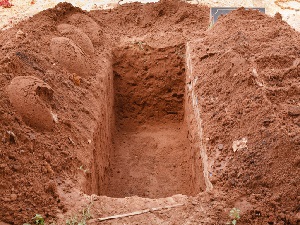
In the experiment, researchers dug four shallow pits and buried corpses donated for research into three of them.
They left the last pit empty – as a control.
One grave had one body, another had three and the third had six buried inside.
'Three differently sized human graves, one control-pit, and surrounding undisturbed ground, were scanned four times between February 2013 and November 2014 using a tripod-mounted terrestrial laser scanner,' researchers wrote in the paper.
'All the disturbed surfaces exhibited measurable and localised elevation change, allowing for separation of disturbed and undisturbed ground.'
The first scan revealed the surface of the graves with the bodies elevated by a few centimetres, before shrinking down between the subsequent two scans.
The ground was likely to have sunk as the bodies decomposed, scientists say.
This minuscule movement of the ground is too subtle for the human eye – especialy when if graves have been disguised or hidden under piles of leaves.
However, Lidar is able to quickly locate the subtle change, even when beamed from a helicopter above a search site.
'This study is the first to quantify elevation changes to human graves over time and demonstrates that terrestrial LIDAR may contribute to multi-modal data collection approach to improve unmarked grave detection,' researchers wrote.
'Piling leaves, or employing some other type of camouflage, will not trick Lidar the same way it might trick the human eye', Dr Corcoran said.
Note that Lidar is a remote sensing technology that measures distance by shooting a laser at a target and analysing the light that is reflected back.
The technology was developed in the early 1960s and uses laser imaging with radar technology that can calculate distances.
It was first used in meteorology to measure clouds by the National Center for Atmospheric Research.
The term lidar is a portmanteau of 'light and 'radar.'
Lidar uses ultraviolet, visible, or near infrared light to image objects and can be used with a wide range of targets, including non-metallic objects, rocks, rain, chemical compounds, aerosols, clouds and even single molecules.
A narrow laser beam can be used to map physical features with very high resolution.
This new technique allowed researchers to map outlines of what they describe as dozens of newly discovered Maya cities hidden under thick jungle foliage centuries after they were abandoned by their original inhabitants.
Aircraft with a LiDAR scanner produced three-dimensional maps of the surface by using light in the form of pulsed laser linked to a GPS system.
The technology helped researchers discover sites much faster than using traditional archaeological methods.


Murder victims buried in unmarked graves could soon be found using pulses of laser light beamed from a helicopter, new research shows
Murder victims buried in unmarked graves in remote areas could soon be found using pulses of laser light, new research has shown.Laser light known as Lidar – a portmanteau of 'light and 'radar' – could be beamed from a helicopter to create 3D maps of remote areas to help police search teams.
Scientists believe Lidar could quickly reveal places where ground has sunk by a few centimetres, caused by decomposing bodies buried beneath the ground.
This sinking movement is too subtle for the naked eye to detect, especially when the grave has been scattered with leaves or debris, scientists say.
The latest findings could help police search teams quickly narrow down their efforts when looking for bodies in remote areas.
Lidar is a remote sensing technology that measures distance by shooting a laser at a target and analysing the amount of light that is reflected back.
The technology was first used in meteorology to measure clouds by the National Centre for Atmospheric Research.
A number of autonomous vehicle companies, including Uber, also use Lidar to navigate roads without human assistance.
Aircrafts fitted with a Lidar scanner can produce three-dimensional maps of the surface by linking the laser to a GPS system.
Katie Corcoran of Oak Ridge National Laboratory, in Tennessee, used this method to measure how the surface of shallow, unmarked graves change over time, according to the New Scientist.
'Unmarked graves are difficult to locate once the ground surface no longer shows visible evidence of disturbance, posing significant challenges to missing person investigations', researchers wrote in the paper, which is published in Forensic Science International.
In the experiment, researchers dug four shallow pits and buried corpses donated for research into three of them.
They left the last pit empty – as a control.
One grave had one body, another had three and the third had six buried inside.
'Three differently sized human graves, one control-pit, and surrounding undisturbed ground, were scanned four times between February 2013 and November 2014 using a tripod-mounted terrestrial laser scanner,' researchers wrote in the paper.
'All the disturbed surfaces exhibited measurable and localised elevation change, allowing for separation of disturbed and undisturbed ground.'
The first scan revealed the surface of the graves with the bodies elevated by a few centimetres, before shrinking down between the subsequent two scans.
The ground was likely to have sunk as the bodies decomposed, scientists say.
This minuscule movement of the ground is too subtle for the human eye – especialy when if graves have been disguised or hidden under piles of leaves.
However, Lidar is able to quickly locate the subtle change, even when beamed from a helicopter above a search site.
'This study is the first to quantify elevation changes to human graves over time and demonstrates that terrestrial LIDAR may contribute to multi-modal data collection approach to improve unmarked grave detection,' researchers wrote.
'Piling leaves, or employing some other type of camouflage, will not trick Lidar the same way it might trick the human eye', Dr Corcoran said.
Note that Lidar is a remote sensing technology that measures distance by shooting a laser at a target and analysing the light that is reflected back.
The technology was developed in the early 1960s and uses laser imaging with radar technology that can calculate distances.
It was first used in meteorology to measure clouds by the National Center for Atmospheric Research.
The term lidar is a portmanteau of 'light and 'radar.'
Lidar uses ultraviolet, visible, or near infrared light to image objects and can be used with a wide range of targets, including non-metallic objects, rocks, rain, chemical compounds, aerosols, clouds and even single molecules.
A narrow laser beam can be used to map physical features with very high resolution.
This new technique allowed researchers to map outlines of what they describe as dozens of newly discovered Maya cities hidden under thick jungle foliage centuries after they were abandoned by their original inhabitants.
Aircraft with a LiDAR scanner produced three-dimensional maps of the surface by using light in the form of pulsed laser linked to a GPS system.
The technology helped researchers discover sites much faster than using traditional archaeological methods.
Views: 704
©ictnews.az. All rights reserved.
Similar news
- The mobile sector continues its lead
- Facebook counted 600 million active users
- Cell phone testing laboratory is planned to be built in Azerbaijan
- Tablets and riders outfitted quickly with 3G/4G modems
- The number of digital TV channels will double to 24 units
- Tax proposal in China gets massive online feedback
- Malaysia to implement biometric system at all entry points
- Korea to build Green Technology Centre
- Cisco Poised to Help China Keep an Eye on Its Citizens
- 3G speed in Azerbaijan is higher than in UK
- Government of Canada Announces Investment in Green Innovation for Canada
- Electric cars in Azerbaijan
- Dominican Republic Govt Issues Cashless Benefits
- Spain raises €1.65bn from spectrum auction
- Camden Council boosts mobile security