

Date:31/07/12
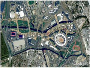
 In time for the Olympic opening ceremony, Google released a huge update of aerial and satellite imagery for both Google Maps and Google Earth, including for the Olympic Park in London.
Google has added fresh high-resolution aerial and satellite imagery to its mapping services for 25 cities and 72 countries.
Among the imagery to get an update is the Olympic Park, London, where athletes around the world are currently vying for medals in the London 2012 games.
Google noted on its LatLong blog that the pictures show the "final construction touches" being added to the East London stadium, suggesting the images are no more than a month old.
More than 20 U.S. cities have been also updated with 45-degree imagery, which Google users to build its urban 3D models, as part of the refresh. Meanwhile, other major European cities in the U.K., Spain, and Germany also saw upgraded satellite imagery, as did parts of Latin and South America, the Middle East, and Australia.
The new imagery will be available in Google Maps, the online mapping service, as well as Google Earth, the downloadable desktop application.
The refresh comes only a fortnight after Microsoft updated Bing Maps with high-resolution "Bird's Eye" imagery, which allows the viewer to see landmarks and cities from a 45-degree angle, with photos taken from low-flying aircraft rather than satellites.
In the past month, Google has also updated its maps of Antarctica, by adding street-level imagery of the ceremonial South Pole.
Google Maps, Earth updated with high-resolution imagery
 In time for the Olympic opening ceremony, Google released a huge update of aerial and satellite imagery for both Google Maps and Google Earth, including for the Olympic Park in London.
Google has added fresh high-resolution aerial and satellite imagery to its mapping services for 25 cities and 72 countries.
Among the imagery to get an update is the Olympic Park, London, where athletes around the world are currently vying for medals in the London 2012 games.
Google noted on its LatLong blog that the pictures show the "final construction touches" being added to the East London stadium, suggesting the images are no more than a month old.
More than 20 U.S. cities have been also updated with 45-degree imagery, which Google users to build its urban 3D models, as part of the refresh. Meanwhile, other major European cities in the U.K., Spain, and Germany also saw upgraded satellite imagery, as did parts of Latin and South America, the Middle East, and Australia.
The new imagery will be available in Google Maps, the online mapping service, as well as Google Earth, the downloadable desktop application.
The refresh comes only a fortnight after Microsoft updated Bing Maps with high-resolution "Bird's Eye" imagery, which allows the viewer to see landmarks and cities from a 45-degree angle, with photos taken from low-flying aircraft rather than satellites.
In the past month, Google has also updated its maps of Antarctica, by adding street-level imagery of the ceremonial South Pole.
Views: 764
©ictnews.az. All rights reserved.Similar news
- 24% of U.S. Adults have made phone calls on the Internet
- UNESCO puts sustainable learning online
- Australia gives incentives for the use of telehealth
- US launches computer programme for poor kids
- UN declares web access as human right
- Facebook growth slows in stalkerbase heartlands
- One Third of Millionaires Use Social Media
- Facebook Seeks Bigger Role in Software for Mobile Apps
- Icann increases web domain suffixes
- IBM launches new social networking platform for enterprises
- Google Notches One Billion Unique Visitors Per Month
- Internet providers cut international channel renting costs by 60%
- Azerbaijan launches standard time on internet
- Icann launches facility to ease DNSSec adoption
- Social network data mining yields worrying results for traditional media


