

Date:29/12/15
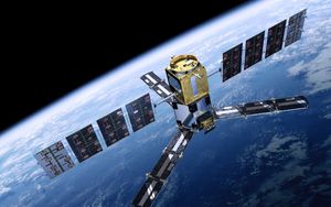
 China on Tuesday launched its most sophisticated observation satellite, Gaofen-4, as part of the country’s high-definition (HD) earth observation project.
Gaofen-4 was launched from the Xichang Satellite Launch Center in the southwestern province of Sichuan aboard a Long March-3B carrier rocket, according to the State Administration of Science, Technology and Industry for National Defense (SASTIND).
Gaofen-4 is China’s first geosynchronous orbit HD optical imaging satellite and the world’s most sophisticated HD geosynchronous orbit remote sensing satellite, according to Xu Dazhe, head of SASTIND and China National Space Administration.
The successful launch of Gaofen-4 was the 19th space mission in this year. It will be used for disaster prevention and relief, surveillance of geological disasters and forest disasters, and meteorologic forecast.The Gaofen project aims to launch seven high-definition observation satellites before 2020.
Different from Gaofen-1 and Gaofen-2 in low orbits (600-700 km) around the earth, Gaofen-4 is located at the orbit 36,000 kilometers away from the earth and moves synchronously with the earth.It can "see" an oil tanker on the sea with a huge CMOS camera, reaching the best imaging level among global high-orbit remote sensing satellites, according to Li Guo, chief designer of Gaofen-4, TASS reports.
China launches HD earth observation satellite
 China on Tuesday launched its most sophisticated observation satellite, Gaofen-4, as part of the country’s high-definition (HD) earth observation project.
Gaofen-4 was launched from the Xichang Satellite Launch Center in the southwestern province of Sichuan aboard a Long March-3B carrier rocket, according to the State Administration of Science, Technology and Industry for National Defense (SASTIND).
Gaofen-4 is China’s first geosynchronous orbit HD optical imaging satellite and the world’s most sophisticated HD geosynchronous orbit remote sensing satellite, according to Xu Dazhe, head of SASTIND and China National Space Administration.
The successful launch of Gaofen-4 was the 19th space mission in this year. It will be used for disaster prevention and relief, surveillance of geological disasters and forest disasters, and meteorologic forecast.The Gaofen project aims to launch seven high-definition observation satellites before 2020.
Different from Gaofen-1 and Gaofen-2 in low orbits (600-700 km) around the earth, Gaofen-4 is located at the orbit 36,000 kilometers away from the earth and moves synchronously with the earth.It can "see" an oil tanker on the sea with a huge CMOS camera, reaching the best imaging level among global high-orbit remote sensing satellites, according to Li Guo, chief designer of Gaofen-4, TASS reports.
Views: 1365
©ictnews.az. All rights reserved.Similar news
- Mobile operators of national market to reduce roaming tariffs
- Iran vows to unplug Internet
- China Targeting Telecoms in Corruption Probe
- Bangladesh to use electronic voting system for next elections
- Philippine IT sector to launch five-year digital strategy plan
- Russian Premier Vladimir Putin meets ITU Secretary-General Hamadoun Touré
- US lawmakers propose to regulate use of geolocation data
- Unlimited mobile data plans dying as telcos gear up for cloud future
- Europe at risk of falling behind US and Asia on 4G use
- Netherlands first to regulate on net neutrality
- Korean Co Takes Aim At Display Patents
- Regulators, Banks Look for IT Hires After Breakdowns
- Electron transactions spreading
- Schools in remote rural areas will connect to the single database via network without SIM
- Obama to Personally Tweet From Twitter Account


