

Date:24/08/18
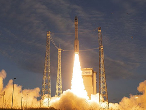
 Europe launched a rocket from French Guyana on Wednesday, to put a satellite into orbit as part of what company Arianespace called the world’s first space mission to map the Earth’s wind on a global scale.
The launch took place at 9.20pm GMT after a 24-hour delay due to adverse weather conditions. The flight was scheduled at just under 55 minutes from liftoff to separation of the satellite.
The satellite – named Aeolus after the guardian of wind in Greek mythology – will be placed at an altitude of 320km (200 miles) above the Earth.
It is part of the Copernicus project, a joint initiative of the European Union and the European Space Agency (ESA) to track environmental damage and aid disaster relief operations.
Aeolus is equipped with a single instrument: a Doppler wind lidar – an advanced laser system designed to accurately measure global wind patterns from space.
“This mission will thus provide much-needed data to improve the quality of weather forecasting as well as contributing to long-term climate research,” Arianespace said in its website.
Tropical winds in particular are very poorly mapped because of the almost complete absence of direct observations.
The Doppler lidar transmits short, powerful pulses of laser light toward Earth in the ultraviolet spectrum. Particles in the air – moisture, dust, gases – scatter a small fraction of that light energy back to the transceiver, where it is collected and recorded.
The delay between the outgoing pulse and the so-called “backscattered” signal reveals the wind’s direction, speed and distance travelled.
Once per orbit data is downloaded to a ground station in Svalbard, Norway.
Aeolus is the fifth of the ESA’s planned Earth Explorer missions.
Others already completed or in operation have measured Earth’s gravity and geomagnetic fields, soil moisture, ocean salinity and frozen expanses collectively known as the cryosphere. The new mission is also Arianespace’s 50th launch for the ESA.
Aeolus satellite launched in ‘world-first’ space mission to map Earth’s winds
 Europe launched a rocket from French Guyana on Wednesday, to put a satellite into orbit as part of what company Arianespace called the world’s first space mission to map the Earth’s wind on a global scale.
The launch took place at 9.20pm GMT after a 24-hour delay due to adverse weather conditions. The flight was scheduled at just under 55 minutes from liftoff to separation of the satellite.
The satellite – named Aeolus after the guardian of wind in Greek mythology – will be placed at an altitude of 320km (200 miles) above the Earth.
It is part of the Copernicus project, a joint initiative of the European Union and the European Space Agency (ESA) to track environmental damage and aid disaster relief operations.
Aeolus is equipped with a single instrument: a Doppler wind lidar – an advanced laser system designed to accurately measure global wind patterns from space.
“This mission will thus provide much-needed data to improve the quality of weather forecasting as well as contributing to long-term climate research,” Arianespace said in its website.
Tropical winds in particular are very poorly mapped because of the almost complete absence of direct observations.
The Doppler lidar transmits short, powerful pulses of laser light toward Earth in the ultraviolet spectrum. Particles in the air – moisture, dust, gases – scatter a small fraction of that light energy back to the transceiver, where it is collected and recorded.
The delay between the outgoing pulse and the so-called “backscattered” signal reveals the wind’s direction, speed and distance travelled.
Once per orbit data is downloaded to a ground station in Svalbard, Norway.
Aeolus is the fifth of the ESA’s planned Earth Explorer missions.
Others already completed or in operation have measured Earth’s gravity and geomagnetic fields, soil moisture, ocean salinity and frozen expanses collectively known as the cryosphere. The new mission is also Arianespace’s 50th launch for the ESA.
Views: 361
©ictnews.az. All rights reserved.Similar news
- Azerbaijani project to monitor disease via mobile phones
- Innovative educational system to be improved under presidential decree
- NTRC prolongs license of two TV and radio organizations for 6 years
- Azerbaijan establishes e-registry for medicines
- Azerbaijani museum introduces e-guide
- Nar Mobile opens “Nar Dunyasi” sales and service center in Siyazan city
- International conference on custom electronic services held in Baku
- OIC secretary general to attend COMSTECH meeting in Baku
- Azerbaijan develops earthquake warning system
- New law to regulate transition to digital broadcasting in Azerbaijan
- Azerbaijani State Social Protection Fund introduces electronic digital signature
- Intellectual traffic management system in Baku to be commissioned in December
- Tax Ministry of Azerbaijan started receiving video-addresses
- World Bank recommends Azerbaijan to speed up e-service introduction in real estate
- Azerbaijan to shift to electronic registration of real estate


